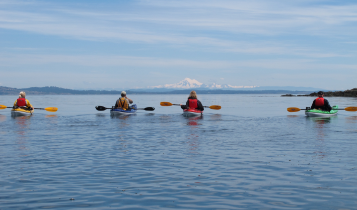
Kayaking to Esquimalt Harbor & Cole Island
The Esquimalt Lagoon to Cole Island paddle is an excellent day trip which can take a couple of hours or half a day or more depending on how much you would like to explore. When you consider that this route encompasses a migratory bird sanctuary, beautiful natural areas, many interesting historical sites and a busy, working naval harbour, best to allow yourself lots of time.
Boating in Esquimalt Lagoon is a controversial topic due to the disturbance of wildlife. The Canadian Wildlife Service in co-operation with Esquimalt Lagoon Stewardship Initiative are considering banning paddlers from Esquimalt Lagoon. Others believe that boating in the lagoon provides a rare and unique opportunity to experience nature in lagoon first hand and learn about the wildlife found here. Whatever you choose to do be respectful of where you paddle and try your best not to disturb the wildlife living here. Be aware that the rules for paddling here may change.
There are public restrooms at the west end of the lagoon on the ocean side.
The Route
It is easiest to launch is on the lagoon side, near the bridge, with its protected gravel beach. There is a parking area on the right just after you cross the bridge. From here you can explore the lagoon. The lagoon is very shallow at low tides and may prevent you from going very far up the lagoon, but if you can there are spectacular views of Hatley Castle, so it is worth the paddle. Hatley Castle was completed in 1908 by the coal baron Robert Dunsmuir. For many years, until 1994, it was Royal Roads Military College and it is now home to Royal Roads University.
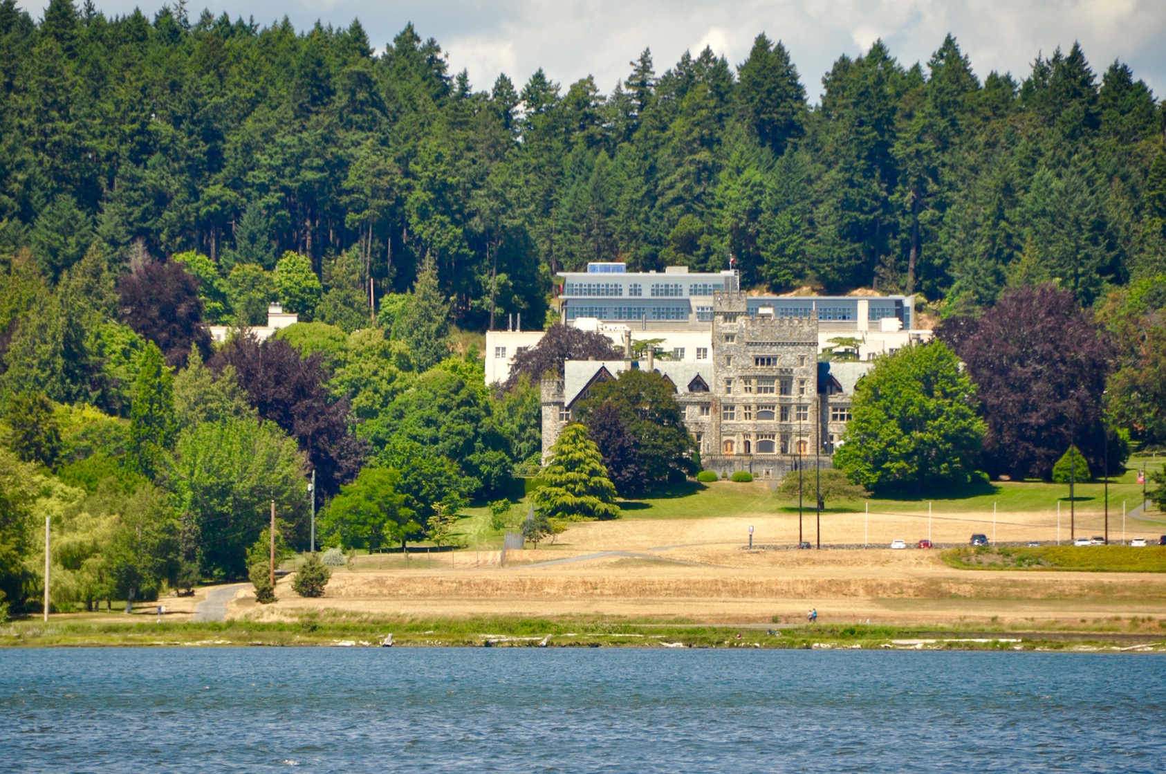
Hatley Castle – Royal Roads University
Esquimalt Lagoon is a Migratory Bird Sanctuary and depending on the time of year, you will find a huge variety of bird life here including; Mallard Ducks, American Wigeons, Pintail Ducks, Mute Swans, Scaup, Cormorants, American Coot, Great Blue Herons, Eagles, Ospreys, Glaucous-winged Gulls, Belted Kingfisher, Crows, Ravens, Hooded Mergansers, Common Mergansors, Red-Breasted Mergansors, Buffle Heads, Common Golden Eye. Green Winged Teal, Canada Geese, Pie Billed Grebes, and many more. River otters are commonly seen swimming the waters of the lagoon and the odd mink and raccoon can be seen prowling the shoreline.

Esquimalt Lagoon
You don’t have to head up island to see giant trees! The land above Esquimalt Lagoon contains trees that are among the top 10 biggest Douglas Fir trees in BC. There is a fantastic network of trails around Royal Roads University that make for great exploration.
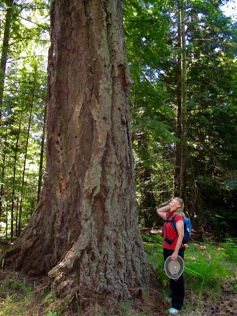
Big Trees in Hatley Park
The east end of the lagoon is quite shallow with large sandy flats, and if you look down in the right spots you will notice the seafloor is covered in sand dollars.
Caution: Strong Currents Flow In and Out of the Lagoon
Quite strong currents flow in and out of entrance, so once you are ready to head out, paddle under the bridge being very careful not to get pushed up against the bridge pilings or other obstructions depending on the direction of flow. As you head for open water be careful of incoming waves, which can break over the shallow bars at the entrance to the lagoon.
On your left you will pass by Fort Rod Hill National Historic Park. Fort Rod Hill is a coastal artillery fort built in the late 1890s to defend Victoria and the Esquimalt Naval Base. Next you will round Fisgard Island, now joined by a causeway, and Fisgard Lighthouse. This spectacular structure is the oldest lighthouse on the BC Coast, completed in 1865.
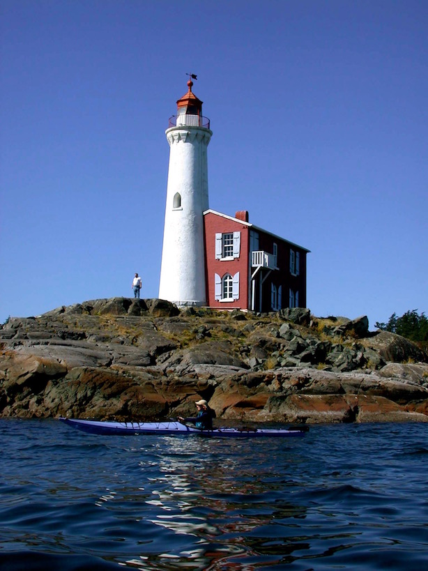
Fisgard Lighthouse
Once around the point, continue north into Esquimalt Harbour. On your right you will pass by the Royal Canadian Navy Dockyards and the Esquimalt Graving Docks. On your left you will pass by more of Fort Rod Hill followed by more navy docks. Continue following the shoreline, which is Ministry of National Defense property. As you approach the end of the harbour, you will see Cole Island set in the middle of the bay. It can be clearly distinguished by the old brick structure on the southwest side of the island.
Important Note: Esquimalt Harbour is now a controlled access area. All visitors must contact the King’s Harbour Master prior to entering, moving within or departing the harbour. Use VHF Channel 10 or 250-363-2160 on your phone.
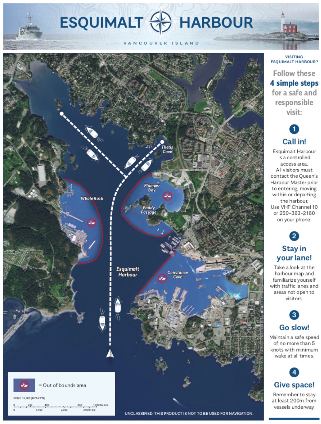
Esquimalt Harbour Movement Rules
Cole Island is a National Historic Site. The buildings you see are the remains of the Royal Navy’s ammunition depot dating back to 1859. These spectacular brick structures drop right into the water and make for some great photo opportunities. Cole Island is now cared for by the Friends of Cole Island Society under the auspices of the Provincial Heritage Branch. The FoCIS have installed a dock making access to the island much easier and visitors are welcome from sun-up until sun-down.
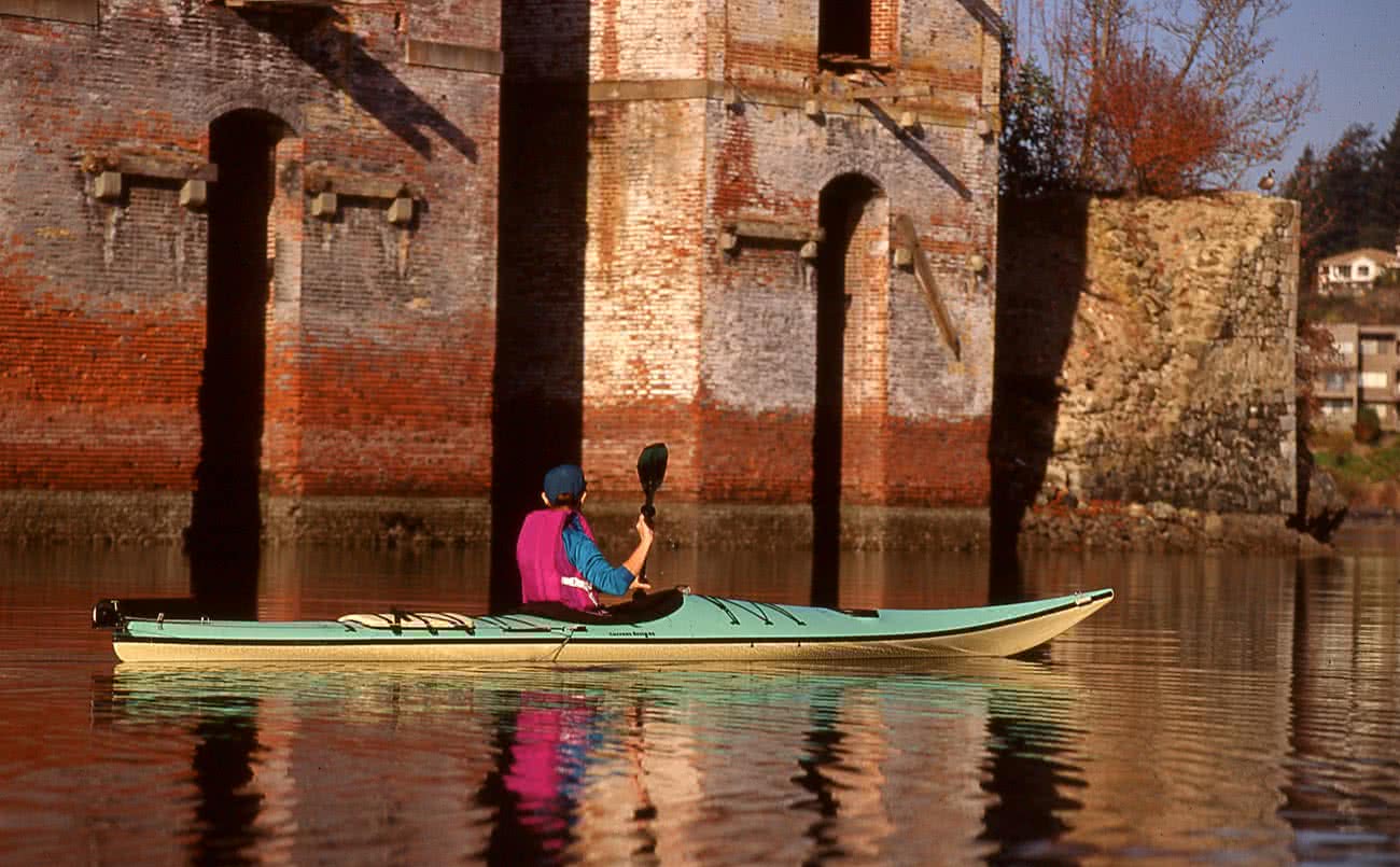
Royal Navy Ammunition Depot on Cole Island
From Cole Island, you can make your way back the way you came or you can head up under the 6 Mile Bridge, depending on the tides, as it can become quite shallow at the head of the inlet, exposing mud flats. If tidal conditions are right you can paddle a short distance up Mill Stream Creek, but please avoid going too far up this creek when the salmon are spawning in the fall. If you like, you can stop for a lunch at the historic 6 Mile Pub, which is located right beside the bridge.
For the return trip you can paddle back the way you came or you can paddle up the western shore. There is a very nice beach in Thetis Cove, part of Portage Park in View Royal. The land on your left up from here is Songhees First Nations, then you will pass the Esquimalt Graving Docks and the Royal Canadian Navy Base – Naden. There is an interesting tower on the point here often mistaken as a lighthouse. Bickford Tower was erected in 1901 as a signalling tower for semaphore signal flags and other means of naval visual communication. Two years after its construction, the tower became obsolete due to the introduction of a military telephone system. Warning: There is a 100 meter security zone around all MoND ships and facilities where civilian vessels (including paddle craft), are not permitted.
Thetis Cove, at Portage Park

Passing Bickford Tower in Esquimalt Harbour
Trip Planning
While most of the lagoon and Esquimalt Harbour offer quite sheltered paddling, there are a couple of places where care needs to be taken. The entrance to the lagoon is very narrow, and strong inflow and outflow currents occur in the passage under the bridge and just beyond. Fisgard Point and the lagoon entrance are also exposed to the Straits of Juan De Fuca so strong winds and large waves can be experienced here. Because of shallow sandbars at the entrance and the potential for wind against out flowing current, breaking waves can commonly occur here. Finally, the east end of the lagoon and the end of Esquimalt Harbour just past Cole Island can be very shallow with unnavigable mudflats at low tides.
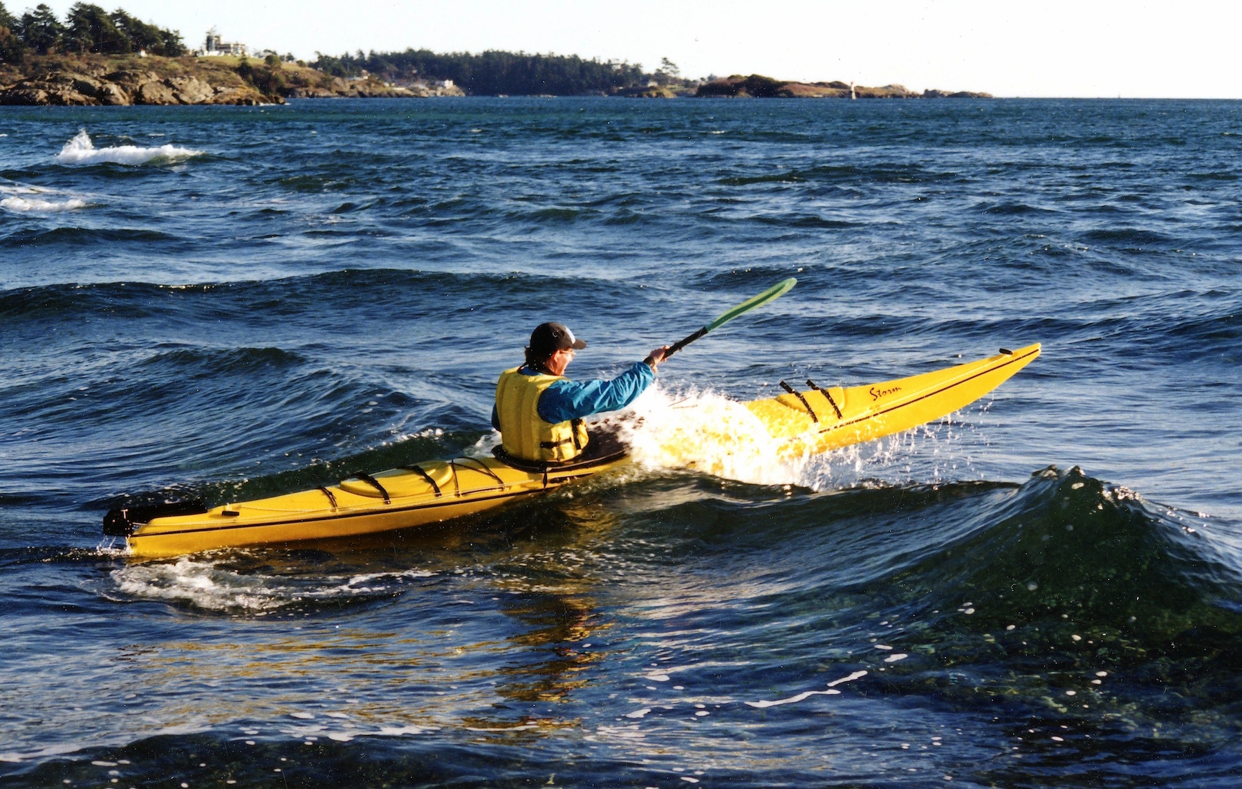
Breaking wave at the entrance to Esquimalt Lagoon
Check the Weather Forecast

Winter can be a spectacular time to paddle Esquimalt Harbour
Most importantly, check the winds (speed & direction) forecast for the day at the sites posted below. Our recommendation for most paddlers is to keep the winds under 10-12 knots or 18 – 24 kph. . Remember that wind against the current will create larger, steeper waves particularly at the entrance to the lagoon.
Here are recommended sites for good wind forecasts:
Check the Tide Tables
There are no current tables for judging currents under the bridge at Esquimalt Lagoon. Once the lagoon has drained and the tide begins to rise again, the water will begin to flow inwards and vice versa at high tide. Typical of inlets like this there will be considerable delay of high and low water in the lagoon from what is posted in the tide tables and what occurs in the surrounding waters of the bay and harbour. With some care, the currents here shouldn’t cause you too many problems. But if in doubt, carry your boats across the road and launch past the bridge. Alternatively, as long as there are no waves, you can launch off the beach on the Juan de Fuca Strait side.
Depending on your goals, your primary concern will be whether there will be enough water to paddle the east end of the lagoon and how far you will be able paddle at the end of Esquimalt Harbor. The tide tables will give you that information.
- The easiest way to check the tides is with very convenient phone app called Aye Tides. Just click ‘Find a Station’ and select Esquimalt Lagoon or Esquimalt.
- Optionally, use the Canadian Tide and Current Tables. They are available online. Find the listing for Victoria and find the date you want to paddle. The table will show you the time of day in the 24 hour clock, and the height of water in either feet or meters. Victoria is unusual in that we often don’t have 2 high and 2 low tides each day, but more predominantly a diurnal tide cycle with 1 high tide and 1 low tide. Don’t get confused by this, just follow the tables. You can fine-tune the times by going to the Secondary Reference Ports on page 135. In this case it is Esquimalt, but you will find the time and water differences from Victoria are minimal. Keep in mind that you must add 1 hour to the tables to allow for daylight savings time from near mid March to the first week of November.
How to Get There
Leaving from Ocean River Sports or Downtown Victoria
Head north on Store St toward Chatham St
Turn right onto Chatham St
Turn left at the 2nd cross street onto Douglas St/Trans-Canada Hwy/BC-1 N
Continue to follow Trans-Canada Hwy/BC-1 N for 7.8 km
Take exit 10 toward View Royal/Colwood
Merge onto Burnside Rd W
Continue onto Island Hwy/Old Island Hwy S/BC-1A W 2.0 km
Turn left onto Ocean Blvd (traffic light just past the Juan De Fuca Recreation Centre)
Continue on Ocean Blvd, shortly there will be a left turn towards Fort Rod Hill, and continue down to the Lagoon, parking on the right after crossing the bridge.
The Paddle Route
Happy Paddling!
Bruce Holland – You can also catch me at Ourhomehas6wheels.com or Brakelightfoto.com