James Island is located in Haro Strait about 1.3 nm (2.4 km) off the east coast of Vancouver Island and is 315 hectares (778 acres) in size with approximately 6 nm (11 km) of shoreline. James Island is privately owned, so while you can’t get out and explore this beautiful Gulf Island, it does make for a delightful circumnavigation with its high sandy bluffs, forested slopes, and a shoreline of gorgeous sandy beaches. On most days you will have spectacular views north to Sidney, east to Sidney Island and the American Gulf Islands and on clear days Mt. Baker will form a beautiful backdrop as you leave the Island View Beach launch.
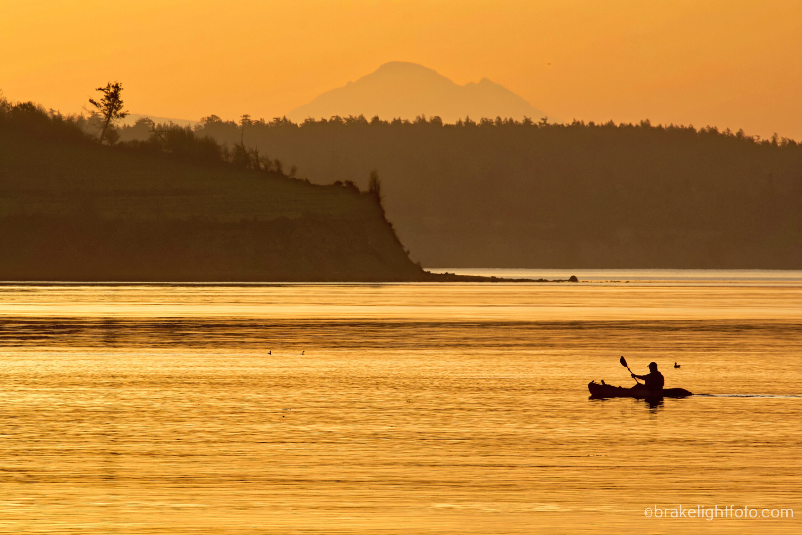
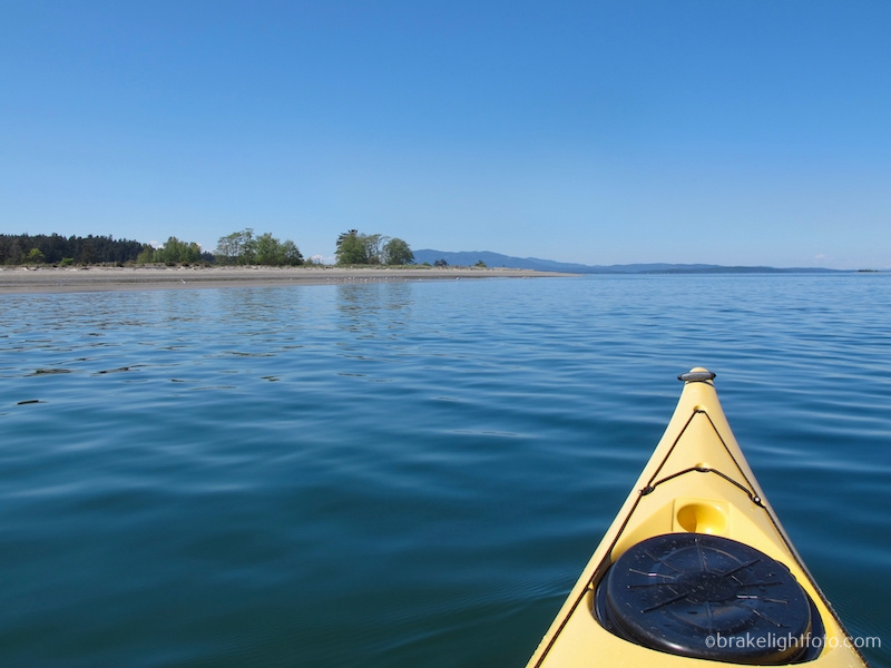
James Island lies just off the north end of Island View Beach
A trip around James Island is fairly easy and relatively safe, even for novice paddlers, if some care and advanced planning is taken. The entire circumnavigation of James Island is about 7 nautical miles (nm) (13 km) including the launch from Island View Beach. It will take the average paddler roughly 2 1/2 – 3 hrs paddling steadily the whole distance, but taking time for breaks, taking pictures and possible delays from adverse currents and wind, you should allow yourself a good half day for this trip.
James Island is 100% privately owned. You can land on the beaches, but please don’t trespass above the high tide mark.
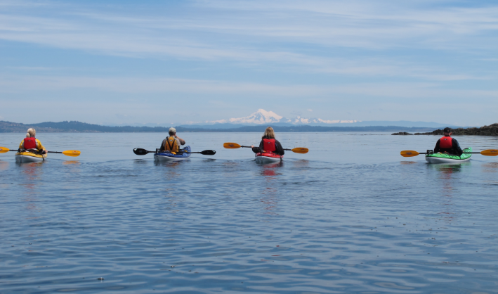
A kayaker in Cordova Channel, just of the southwest end James Island. Mt Baker in the background
History
James Island was named after Sir James Douglas the former Governor of Vancouver Island and British Columbia. The island is located in the traditional territory of the the Tsawout First Nation and they have recently launched a lawsuit suing for the return of the island. The lawsuit alleges that James Island was part of the 1852 treaty with then Governor James Douglas.
James Island was first settled in the 1870’s by farming families, eventually becoming a private hunting ground for sportsmen in the early 1900’s. In 1913, Canadian Explosives Ltd, later Canadian Industries Ltd (CIL), constructed a dynamite plant on the island. The plant operated from 1913 to 1977 and at its peak during World War II, CIL employed 800 workers and produced 900 tonnes of TNT per month. In 1979 the plant and the village were disassembled and removed from the island.
Today
Today the island is privately owned by American cellular billionaire Craig McCaw. There is a Jack Nicklaus designed golf course, six cottages, a seaplane ramp, a runway, and a dock that can accommodate large yachts. A water taxi runs residents and their visitors back and forth from the public dock in Saanichton Bay at the end of James Island Rd. To his credit, McCaw has set some environmental standards for the island, which include the banning of insecticides, all power lines are underground and only electric cars and golf carts are allowed for transportation.
How to Get There
One of the easiest and most popular places to launch for a paddle to James Island is from Island View Beach Regional Park, about a 20-30 minute drive from downtown Victoria. There is lots of free parking and you can launch from the beach or the boat ramp located at the far right of the parking area. An alternative launch site is from a small parking area at the very end of Mt Newton Cross Rd. From here there is a paved path leading down to some gravel beaches on a creek estuary flowing into Saanichton Bay.

Just off the Island View Beach with the sandy cliffs of James Island in the background
The Route
Depending on the weather and currents, you can decide whether to circumnavigate James Island in a clockwise or counter clockwise direction. There will generally always be some current flowing in Cordova and Sidney Channels in one direction or the other. You will have to choose in which direction to paddle with or against the currents. Regardless, be prepared to take advantage of eddies (areas along the shore where the water is flowing counter to the direction of the current) and the slower water moving close to shore. Paddling around James Island is a good and relatively safe place to practice your water reading skills. Be aware of what the water is doing and try as much as possible to work with the currents rather than fight them.
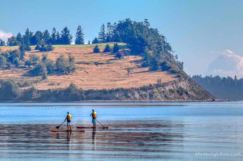
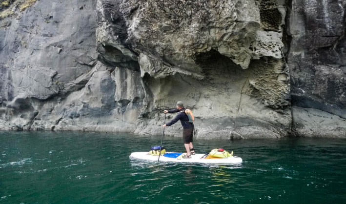
Paddle Boarders just off James Island
What to See
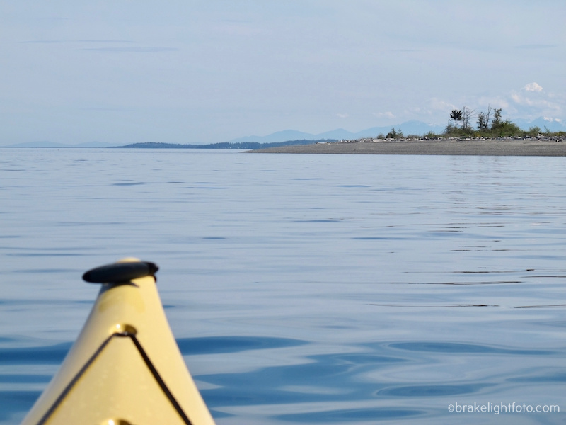
The most noticeable feature of James Island is the large sandy cliff on the south end of the island clearly visible from Island View Beach. Approximately 15,000 years ago, an ice sheet about one kilometre thick covered this area. As the ice advanced, gravel and sand deposited from waters melting along the ice front were over-ridden by the ice and formed into streamlined hills oriented in the direction of the flowing ice. These hills are called drumlins and James island is one of these. Sidney Island and the sandy ridge behind Island View Beach are also drumlins. The sand and gravel beaches surrounding James Island, Sidney Island and the beaches and sandbars of Island View Beach are the product of the erosion of these drumlins.
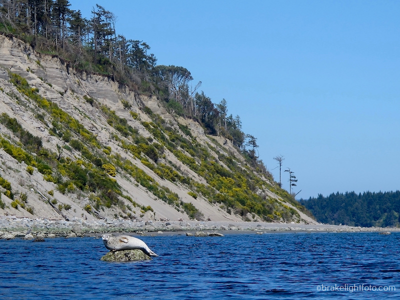
The sandy cliffs on the south end of James Island and a harbour seal
Sandy beaches on the southeast side of James Island
There is a hooked spit on the southwest corner of the James Island where the island’s dock and seaplane ramp are located. In the bay on the east side of the island you will pass a large dock with a loading ramp and a large warehouse building on it, leftovers from the days of the explosives plant.
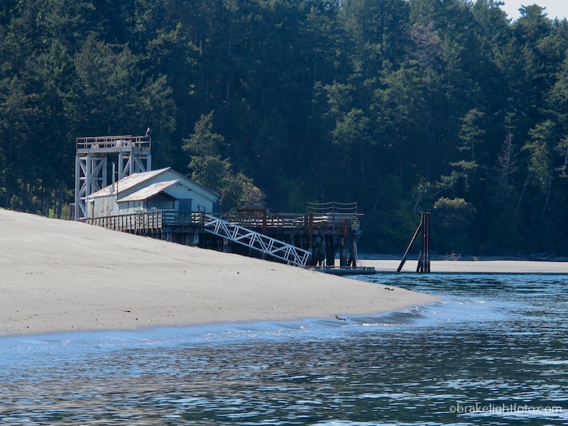
The dock and warehouse on east side of James Island
The northern tip of the island has a sandy spit with a navigation marker. Here, you may find more significant currents as the waters push past the the end of the island. If you happen to be paddling in a counterclockwise direction and meet flooding currents at the here, you can either choose to hug the western shore as tightly as possible to stay out of the fastest moving water or you could ferry across the channel into Saanichton Bay to take advantage of the eddies along the shore there.
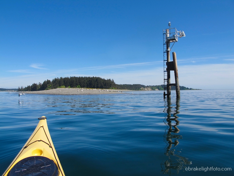
The navigation marker on the northern tip of James Island
If you do decide to cross into Saanichton Bay you will pass by a couple of historic boathouse sitting on log foundations above the rocky shoreline. They are part of Newman Farm Park. What makes this farm particularly special is the farm was owned by the Newman family for its entire 106 year existence, continuously operating as a small mixed farm and changing very little since it’s beginnings in 1867. The park/farm exists in 3 separate parcels of land divided by Central Saanich Rd, the Pat Bay Highway and Lochside Dr. The most eastern parcel has the two restored boathouses on the property which have been made available to the Tsawout First Nation Canoe Club youth paddling program for the storage of their racing canoes and equipment.

The Historic Newman’s Farm Boathouses in Saanichton Bay
Once you round Turgoose Point you will pass the James Island Public Dock before entering Saanichton Bay proper where there is a small river estuary. On the north side of the estuary is Saanichton Bay Park while the south shore is Tsawout First Nations land. Continuing through the bay you will round Cordova Spit, which is a beautiful place to stop for a break.
The river estuary in Saanichton Bay and an alternative launch/landing site
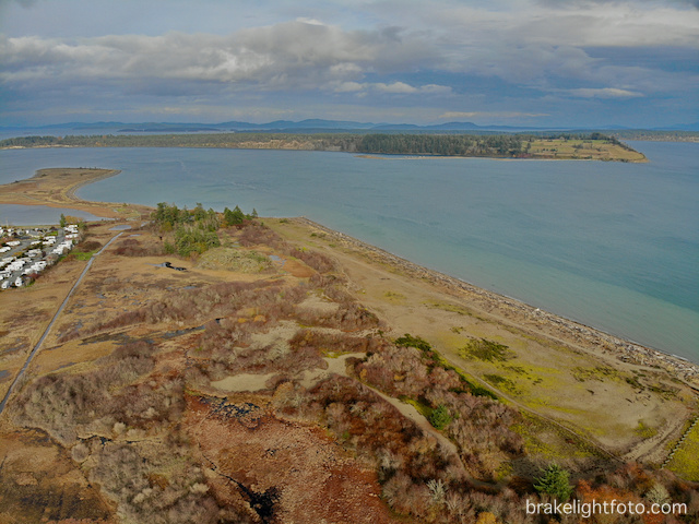
Approaching Cordova Spit from the north
T̸IX̱EṈ (pronounced tee-quan) is the Tsawout name for Cordova Spit. The whole Cordova shore has been home to the Tsawout First Nation and their ancestors for thousands of years. The Tsawout people have fished this shore, collected shellfish and crabs and have hunted birds and marine mammals here. The dry and wetland areas were a rich source of plants for food, medicine and raw materials for tools and implements. At present, the northern half of the spit is parkland owned by Central Saanich, but it is in the process of being turned over to the Tsawout First Nations. The Cordova Spit ecosystem is still very important to Tsawout for traditional and cultural reasons. If you do decide to stop at the spit you are asked to stay on the beaches and the already developed paths and avoid crossing beach berms and dunes to avoid disturbance of rare plants and nesting birds found here.
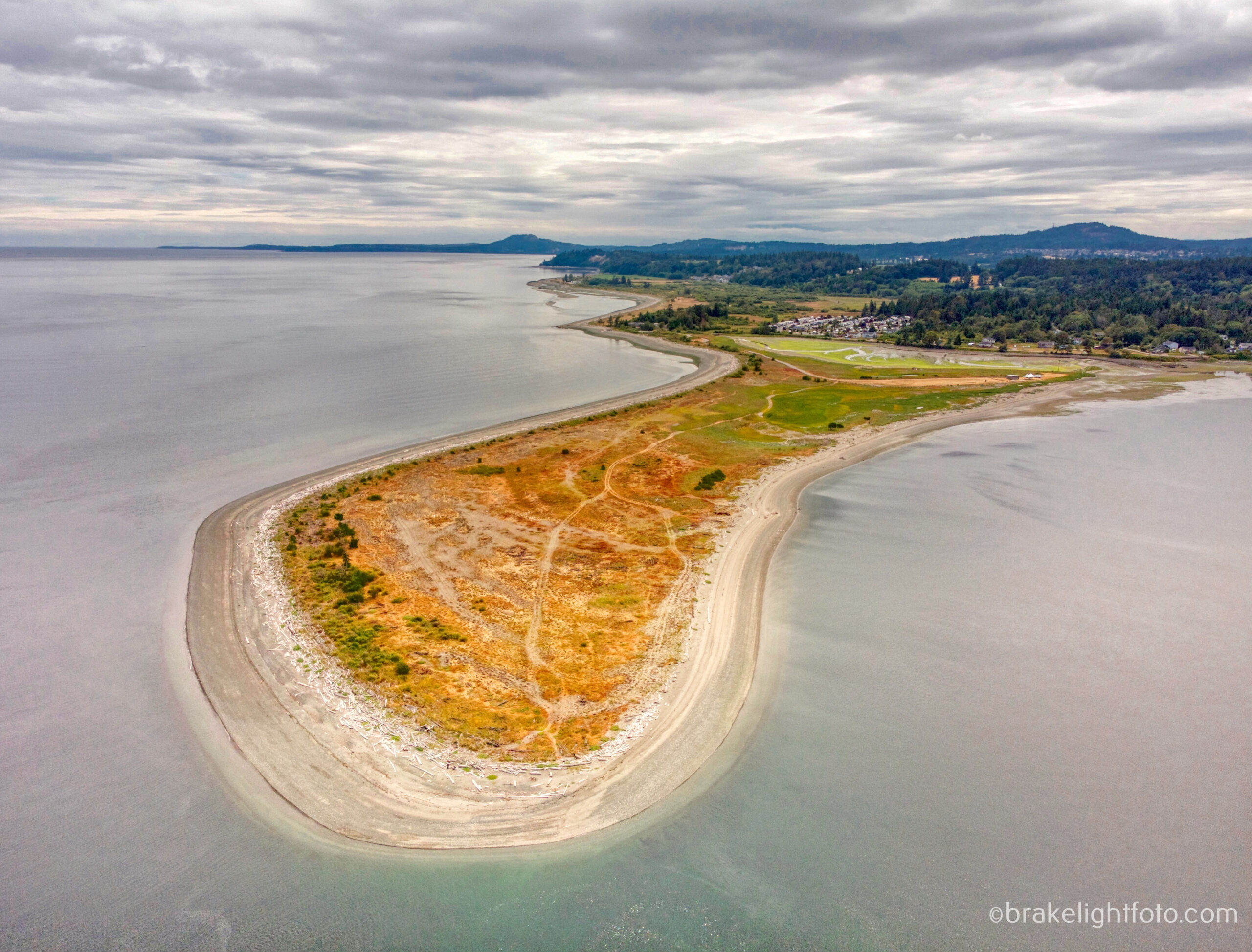
Cordova Spit
Once back on the water you can continue to hug the shore back to the take out at Island View Beach. The currents can be quite strong as they flow around the spit, so be cautious. Depending on the tides you will have to watch the sandbars that form just offshore of the beach that become exposed at low tide. They may impede your passage or, in windy conditions, you may find breaking waves here.

The sand bars off Island View Beach at low tide
Wildlife
There is always some wildlife to be spotted on a trip around James Island including a wide variety of birds such as common murres, cormorants, rhinoceros auklets, black oyster catchers, bald eagles, osprey and many more. It is also very likely you may spot some marine mammals out there. Harbour seals are a common sight, but you will often spot sea lions or Dall’s porpoise swimming by and along the shore you will often glimpse river otters, mink and raccoons.
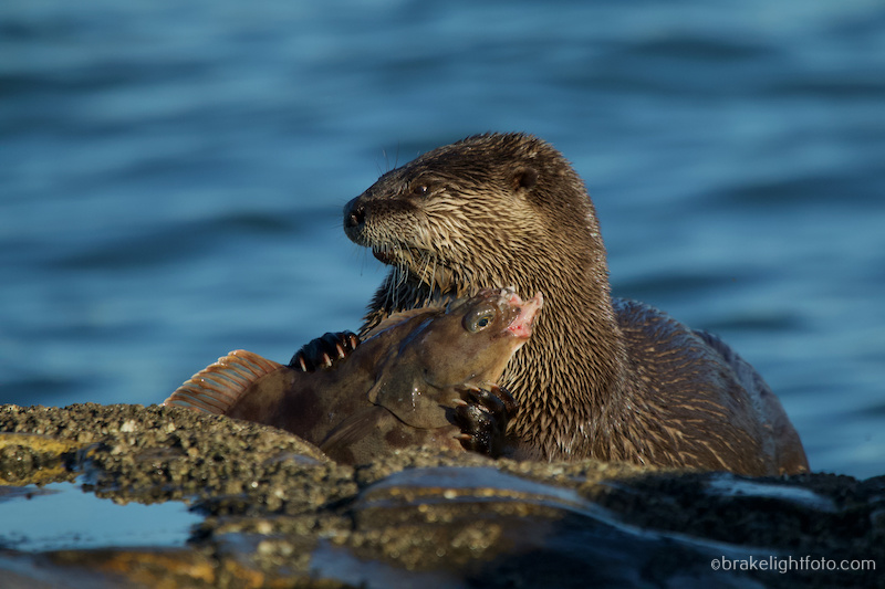
A river otter enjoying a meal
Trip Planning
Check the Weather Forecast
The crossing from Island View Beach to James Island is fairly short however, you will be crossing part of Haro Strait and Cordova Channel, both which are very exposed to the possibility of high winds. There are also current flows, which can be up to 2.5 knots in Cordova Channel. With a 3-4 hour circumnavigation there is plenty of time for conditions to dramatically change before you get back. Therefore, it is important that you check the wind (speed & direction) forecast for the day and the current direction so that you can avoid conditions where wind and current are in opposition. The weather can be checked at the sites posted below. Our recommendation for most paddlers is to keep the winds under 10-12 knots or 18 – 24 kph.
Remember that wind against the current will create larger and steeper waves and it can quickly get very rough when the current direction changes.
Here are 2 recommended sites for good wind forecasts:
Windfinder – Kelp Reefs
Enviornment Canada – Haro Strait
A stormy day on Island View Beach looking across Cordova Channel at James Island
Check the Currents
It is important to distinguish the difference between tides and currents. Tide stations only measure the depth of the water at high and low water at a particular location. A current station, measures the speed and direction of the water moving past a location. Also be aware that times of high and low tide do not correspond to changes in current direction, so you cannot use tide tables to reliably predict currents. This is particularly relevant around southern Vancouver Island. Keep in mind that a current flow of 2 nautical miles per hours or more is considered strong.
Using the Canadian Tide & Current Tables
You can find the Canadian Tide & Current Tables online. You will need Volume 5 and you can access the full publication at this link: Canadian Tide & Current Tables. Make sure you get the latest year as they also have previous years available.
Go to Table 4 on page 135 for a listing of the Secondary Current Stations. You will see Haro Strait and Sidney Channel listed here. These are the two closest secondary reference stations to where you will be crossing. Use the Sidney Channel listing. Just above this listing you will see “on/sur RACE PASSAGE, pages 66-69” printed. This means that the main reference station for the area is Race Passage which you will find on pages 66-69.
The times of the turn to Ebb and Turn to Flood (essentially slack water), as well as the time of the maximum current flow are listed in this table. The minus sign refers to the ebb or water flowing out, (a westward direction at Race and southward in Sidney and Haro Straits) and the positive sign is the Flood or inflow (eastward at Race and northward in Sidney and Haro Straits).
Once you have this information, you will use the Sidney Channel information listed on page 135 to find the differences in time and current flow you can expect from Race Passage. The table will tell you that Sidney Channel current runs at about 35% of Race Passage on the Flood and 30% on the Ebb. It also tells you the time differences for the turns and maximum flow expected. For example, if the currents are 4 knots at Race at max flood, expect a max flow of 1.2 knots in Sidney Channel, 1 hr and 30 mins later.
Using the Phone App Aye Tides
Like the online CT&C tables, Aye Tides has limited current information available for more local conditions like Sidney Channel. Kellet Bluff is a current station in Haro Strait close to Henry Island in the US Gulf Islands and will give you an approximation of what to expect.
Get Out There but be Safe!
One of the joys of living on southern Vancouver Island is we can paddle all year round. That being said, caution should always be exercised as the water is very cold and conditions can change rapidly. If in doubt, change your plans and do a shore paddle.
Happy paddling!
Upgrade Your Skills
If you want to do paddling trips like this but feel that they are out of your comfort zone, consider upgrading your paddling skills by taking some of Ocean River Sport’s intermediate and advanced sea kayaking courses such as Rough Water & Tidal Paddling or Sea Kayak Safety and Rescue. Click this link for more information on these courses and a complete listing of other courses: Intermediate & Advanced Courses
Cheers & Happy Paddling!
Bruce Holland Catch me at Ourhomehas6wheels.com or Brakelightfoto.com
Map